
.png)


OUR EXPERTISE
Integrated intelligence for sustainable territories and institutions
Green Angel Innovations combines geospatial intelligence, environmental governance and strategic advisory to help institutions understand complex territories, manage risk, direct resources and measure results.
Our capabilities can be engaged as focused technical services or integrated within multidisciplinary programmes, institutional assignments and consortium-led delivery.
From evidence to decision-ready intelligence
We connect spatial data, environmental evidence, programme information and institutional priorities to produce analysis, systems and advisory outputs that can be used in real decision-making — for governments, development partners, investors, implementing organisations and research institutions.
01
Geospatial intelligence and earth observation
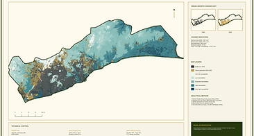
Transforms satellite imagery, field information and institutional datasets into maps, geodatabases, dashboards and decision-ready spatial intelligence.
02
_edited.jpg)
Environmental Governance and Safeguards
Connects regulatory requirements with practical environmental management, stakeholder accountability and institutional decision-making.
03
Climate Resilience and Landscape Restoration
Assesses climate and ecosystem risk, identifies restoration priorities and builds monitoring systems for landscape change and adaptation performance.

04

Territorial, Urban and Regional Planning
Integrates environmental, social, land-use and infrastructure evidence to support planning across interconnected systems and administrative boundaries.
05
MEL and Decision Support
Designs monitoring, evaluation and learning systems that connect programme indicators with geography to strengthen accountability and adaptive management.
_HEIC.png)

CROSS-CUTTING CAPABILITIES
Embedded across every assignment
Stakeholder Engagement and Institutional Coordination
Facilitating consultation, alignment and collaboration across public institutions, communities, development partners and technical stakeholders.
Developing practical skills, guidance, training tools and institutional capability in GIS, environmental governance and reporting.
Capacity building and knowledge transfer
Strengthening data standards, quality, documentation, institutional ownership and communication of technical evidence.
Data governance and technical reporting
Translating analysis into strategies, frameworks, implementation pathways and investment priorities.
Strategic Advisory and Programme Design
Applied across food systems, infrastructure, human settlements, climate programmes and natural resource governance
HOW OUR EXPERTISE CONNECTS
One Integrated advisory model
Environmental Governance
MEL & Decision
Geospatial Intelligence
Climate Resilience
Territorial Planning
Our value lies in the ability to connect spatial intelligence, environmental evidence and institutional systems within one evidence-to-impact framework.
TYPICAL ASSIGNMENT OUTPUTS
Decision-ready outputs for institutions
SPATIAL AND DIGITAL PRODUCTS
Spatial databases
Interactive maps and dashboards
Field-data systems
INSTITUTIONAL PRODUCTS
Spatial Governance and safeguard frameworks
Monitoring frameworks
Institutional guidelines
ANALYTICAL PRODUCTS
Spatial and risk analyses
Scenario models
Technical and baseline studies
STRATEGIC PRODUCTS
Strategies and implementation plans
Investment-prioritisation tools
Policy and advisory reports
HOW WE CAN CONTRIBUTE
Engagement models
Lead Technical Assignment
Delivery of a complete technical or advisory assignment from inception through reporting and institutional handover.
Specialist Workstream
Delivery of a defined geospatial, environmental, MEL or territorial-governance component within a larger programme.
Consortium Partnership
Participation as a specialist, national, regional or implementation partner within multidisciplinary bids.
Institutional Capacity Support
Training, systems strengthening, technical backstopping and knowledge transfer for public and development institutions.